2010 Tampa, FL (City Wall Maps)
Price 159.50 USD
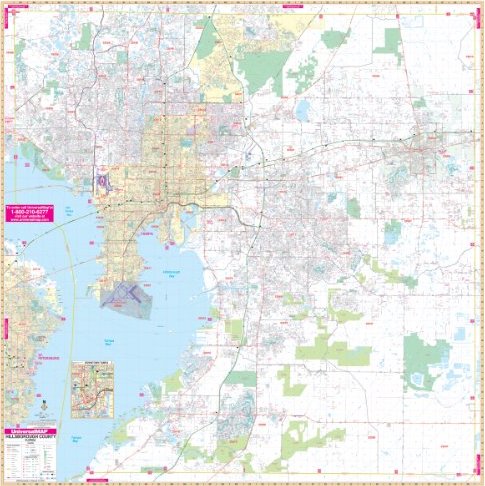
The 2010 edition of Metro Tampa/Hillsborough County, Florida Wall Map by Universal Map measures 72 x 72 (6" W x 6" H) and features complete street detail at a scale of 1 = 2,816 feet. Contains up-to-date cartography with new streets and changes. Printed in color with a laminated, markable and washable surface. Streets indexed in a separate book. Boundaries: North: To the Pasco County Line; South: To the Manatee County Line; East: To the Polk County Line; West: To the Pinellas County Line. Includes a detailed inset of Downtown Tampa. The special features and data are as follows: all streets, all highways, educational facilities, government buildings, shopping centers, hospitals, ZIP codes and boundaries, post offices, fire and police stations, airports, cemeteries, recreational parks, golf and country clubs, points of Interest, city limits and annexations, railroads, block numbers, water features, longitude and latitude lines, and section/township/range lines. Framing rails are included on top and bottom for easy wall mounting. Railed wall maps can be turned into pull down maps on spring rollers for an additional $30.