2010 Jacksonville, FL (City Wall Maps)
Price 159.50 USD
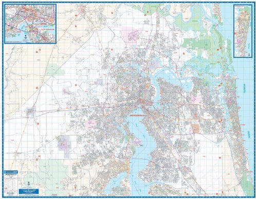
The 2010, 5th edition of Jacksonville, Florida Wall Map is published by Universal map. Measures 76 W x 60 H (6"4 W x 5" H) with complete street detail at a scale of 1 =3,017 feet. Provides up-to-date cartography with new streets and changes. Printed in color with a markable/washable-laminated surface. Contains hanging rails mounted top and bottom. Indexed in a separate book. Covers all of Duval County with the following boundaries: North: to the Nassau/Duval County line; South: includes Orange Park; community of Doctor"s Inlet; Fruit Cove and Ponte Vedra in St. John"s County; East: to the Atlantic Ocean; West: to the Baker County line. Includes insets of Fernandina Beach and Downtown Jacksonville. Details, information, and data included are as follows: all streets and highways, government buildings, airports, golf courses and country clubs, railroads, ZIP code numbers/boundaries, shopping centers, recreational parks, mileage circles, cemeteries, educational facilities, hospitals, post offices, city limits/annexations, fire/police stations, section/township/range lines, new interstate exit numbers, and miscellaneous points of interest. Railed wall maps can be turned into pull down maps as a $30 option.