British Virgin Islands 1:110 000 / 75 000 Guide & Dive Map, waterproof, 2012 edition


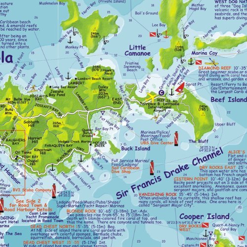
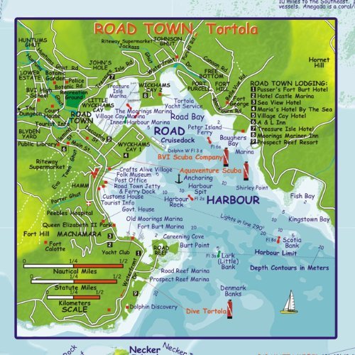
British Virgin Islands 1:110 000 / 75 000 Guide & Dive Map, waterproof FRANKO, 2012 edition This map is waterproof and tear-resistant, highly durable in tropical climate of the Caribbean. It is double-sided to provide the best balance between an excellent scale and a convenient sheet size (size 67 x 47 cm / 26 x 18.5 in), with topographic and tourist information.It is an outstanding, accurate chart of the islands, and it is a good map of the roads and features of each island as well. Every notable scuba and snorkeling site is shown, as are main boating routes. SIDE ONE is the finest dive map to date in the Caribbean, with beautiful nature of the layout of the islands, at scale 1:75,000 (1 inch = 1.2 miles). In addition to the artwork depicting the islands themselves, there is a little inset of BVI"s most famous dive site of all - The Wreck of the RMS Rhone. Another inset shows the enlarged island of Anegada at 1:110,000. Added is a gallery of 100+ of BVI"s most beloved colourful fish and other reef creatures as well as some birds.SIDE TWO shows the entire string of islands comprising the BVI at 1:110,000 (1 inch = 1.75 miles). It is on this side that one finds the more remote and less visited island of Anegada, with it"s long horseshoe reef, which has more wreck than we probably know about. The southwest corner of the map shows the island of St. John in the United States Virgin Islands. This side of the map contains descriptions of each of the main islands themselves, with additional information about airlines, ferries, marine park rules, and the Dive Shops, Charter Boats & Live Aboards and Marine Photography studios. Added is an enlargement of Road Town (on Tortola Island) at scale 1:22,000 that shows points of interest, hotels and other facilities.