Oregon Country (U.S. History Wall Maps)
Price 111.08 USD
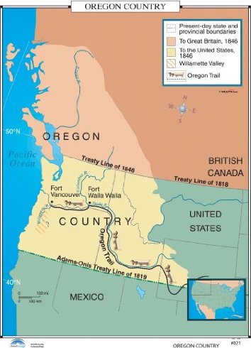
The Oregon Country full-color History Wall Map identifies present-day state and provincial boundaries, British Canada as of 1846, that part of the Oregon Country controlled by the United States in 1846, the Willamette Valley, and the Oregon Trail. These United States History maps, now available from Universal Map, are a valuable visual aid in understanding American History. All maps in this series are markable with a dry erase or water-soluble marker. Durably laminated maps measure 46 x 32 or 36 x 48. Mounted on roller with backboard. Meets U.S. History curriculum requirements.These maps are a new special order item. Please allow 2-4 weeks for delivery on multiple wall map custom sets. This product is ideal for public, private, parochial, and home schools.