2009 Salt Lake City, UT (City Wall Maps)
Price 159.50 USD
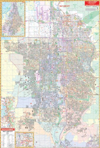
The 2009, 3rd edition Salt Lake City, Utah Wall Map by Universal Map features complete street detail. Measuring 54 x 78 This map is laminated making the map markable and washable. This color map offers up-to-date cartography with new streets and changes. Details and special features include all streets, post offices, hospitals, railroads, mileage circles, time zones, airports, cemeteries, shopping centers, water features, recreational parks, longitude and latitude lines, government buildings, fire and police stations, educational facilities, golf courses and country clubs, ZIP codes and ZIP code boundaries, city limits, and annexations. The area of coverage ranges: North: to the Salt Lake/Davis County line; South: to Camp Williams, SR 92; East: to Wasatch-Cache National Forest; West: to the community of Magna. Insets include Centerville/Bountiful/North Salt Lake City area; vicinity map; and a downtown Salt Lake City map. Framing rails are included on top and bottom for easy wall mounting. Railed wall maps can be turned into pull down maps on spring rollers for an additional $30.