2008 Lexington, KY (City Wall Maps)
Price 159.50 USD
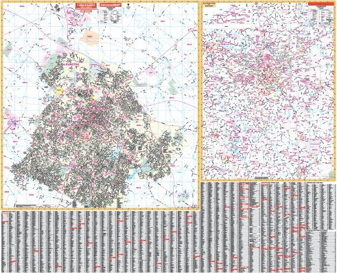
The 2008, 4th. edition Lexington, Kentucky Wall Map by Universal Map features complete street detail at a scale of 1 = 1564 feet. Measures 64 W x 46 H and provides up-to-date cartography with new streets and changes. Printed in color on durable lamination providing a markable and washable surface. Streets are indexed on the face of the map and in a separate book. Framing rails are included on top and bottom for easy wall mounting. Boundaries as follows Section I: North: to Kentucky State Horse Park; South: to Jessamine County line; East: to N. Cleveland Road; West: to Bluegrass Airport & Keeneland Race Track. Section II; Approximately 20 mile radius, major streets only: North: to Sadieville & Cynthiana; South: Junction City, Berea, Sanford, Danville; East: to Winchester; West: Frankfort, Harrodsburg, Lawrenceburg. The special features and data are as follows: all streets and highways, government buildings, airports, golf courses and country clubs, railroads, water features, ZIP codes/ boundaries, shopping centers, recreational parks, mileage circles, cemeteries, educational facilities, hospitals, post offices, city limits and annexations, fire and police stations, prominent horse farms, mileage circles, and miscellaneous points of interest. Railed wall maps can be turned into pull down maps on spring rollers for an additional $30.