2001 Canton, Oh (City Wall Maps)
Price 159.50 USD
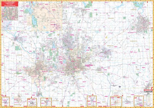
The 2001 edition Canton, Ohio Wall Map by Universal Map provides up-to-date cartography in complete street detail with over 500 new streets and changes. Area of coverage ranges north to the Portage/Stark County line including all of Green"s city limits; south to Malvern, Brewster, and Navarre; east to the Columbiana/Stark County line and Alliance; and west to the Wayne/Stark County line. Provides insets of Wilmot, Beach City, Bolivar, East Sparta, Magnolia, Waynesburg, and Downtown Canton. Shows all streets/highways, government buildings, airports, golf courses/country clubs, railroads, longitude/latitude lines, ZIP codes/boundaries, shopping centers, recreational parks, mileage circles, cemeteries, educational facilities, hospitals, post offices, city limits and annexations, fire/police stations, and more points of interest. Measures 70 by 54 inches, lithographed in 8 colors, laminated, and indexed in a separate book. Framing rails are included on top and bottom for easy wall mounting. Railed wall maps can be turned into pull down maps on spring rollers for an additional $30.