Pyrenees and Andorra (National Geographic: Adventure Map) (Adventure Map (Numbered))
Price 10.46 - 11.95 USD
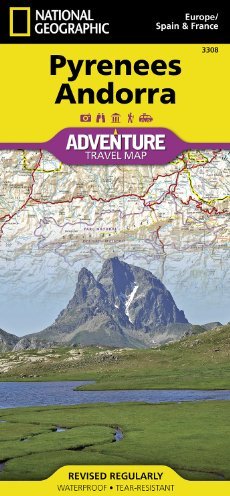

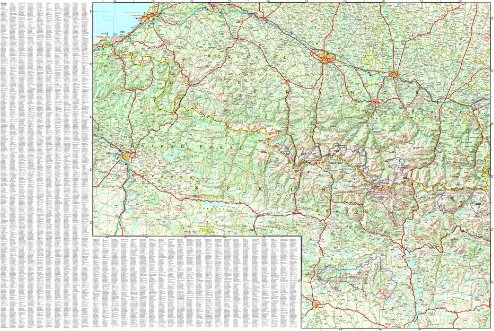
• Waterproof • Tear-Resistant • Travel Map National Geographic"s Pyrenees and Andorra AdventureMap is designed to meet the unique needs of adventure travelers with its durability and accurate information. This folded map provides global travelers with the perfect combination of detail and perspective, highlighting hundreds of points of interest and the diverse and unique destinations within the country. The map includes the locations of cities and towns with a user-friendly index, plus a clearly marked road network complete with distances and designations for major highways, main roads, and tracks and trails for those seeking to explore more remote regions. The front side of the Pyrenees/Andorra map shows the country of Andorra and the eastern half of the Pyrenees including the cities of Narbonne, Carcassone, Pamiers, St-Gaudens, St-Girons, Perpignan in France, and Balaguer, Manresa, and Figueres in Spain. The reverse side of the map stretches from the city of Biarritz on the Bay of Biscay eastward to include Pamplona and Huesca, Spain, and Pau, Tarbes, and the famed pilgrimage site of Lourdes, France. Every AdventureMap is printed on durable synthetic paper, making them waterproof, tear-resistant and tough — capable of withstanding the rigors of international travel. Each is two-sided and can be folded to a packable size of (4.25" x 9.25"); unfolded size is (26" x 38"). Key Features: - Waterproof and tear-resistant - Accurate topography/terrain with a clearly labeled road network - Hundreds of points of interest, including the locations parks and nature reserves, protected lands, historical and cultural attractions - Thousands of place names including towns and natural features; detailed place names index - Important travel networks including airports, lighthouses, ferry routes and rail lines - Updated regularly to ensure accuracy Proceeds from the sale of National Geographic maps go to support the National Geographic Society"s vital exploration, conservation, research and education programs.Folded Size = 4.25 x 9.25Sheet Size = 37.75 x 25.5Scale = 1:275,000