Hook-N-Line Map F202 Offshore Golden Gate- South Section
Price 19.97 - 20.89 USD
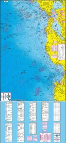
• A 25 inch x 38 inch waterproof two-sided Offshore fishing map from the Golden Gate Bridge area south to Point Sur, California. • This map is a very detailed, two-sided, deep water, waterproof fishing map designed for boat fishermen. • Map F202 shows latitude - longitude lines, depth contours, islands, sea mounts, underwater canyons and well marked fishing locations. The reverse side of this map has listings for the fishing locations with GPS coordinates, water depths and fish species caught for different times of the year. • Map F202 shows many fishing locations with GPS coordinates, water depth and fish species caught there for different times of the year, as well as GPS numbers for fishing spots, marinas, boat ramps and other locations.